
LMB and MMBA have joined forces
SUMMARY: The Michigan Mountain Biking Association has become part of the League of Michigan Bicyclists.
The League of Michigan Bicyclists (LMB) and Michigan Mountain Biking Association (MMBA) have moved forward with a unification to bolster and broaden the voice of the Michigan bicycling community. We recognize that we are all stronger when we work together.
MMBA has become part of the League of Michigan Bicyclists. Through this unification, the MMBA acronym remains, but the name has changed slightly to be the Michigan Mountain Bike Alliance. This retains the well-established MMBA moniker and branding, but also signifies this important organizational shift. As a strategic “Alliance”, MMBA now represents a relationship among people and groups who work together for positive change.
![]()
Mountain biking is a natural fit with LMB’s mission to “improve life through bicycling.” This transition supplements and expands on LMB’s current work and extends our reach throughout the bicycling community, while we maintain progress and attention on existing priorities. A LMB/MMBA unification fits multiple focus areas from LMB’s strategic plan, including plans to “strengthen collaborative partnerships with local trail groups,” “integrate mountain biking clinics into our educational curriculum,” and “plan and implement a membership drive drawing from all types of cyclists.”
Why This is Happening
“LMB has a top-notch organizational structure in place and has done a fantastic job over the past decade advocating for cyclists on our roadways, creating real change, which has enhanced both the rights and safety of cyclists. The MMBA has a long history of securing access to quality trails for off road cyclists. Unifying advocacy efforts for the mutual benefit of Michigan cyclists – road and trail – under one umbrella just makes sense and stands to strengthen the voice of the entire cycling community in our state.” – Jason Aric Jones, Advocacy Director, MMBA, Oct 18, 2022
What’s Happened So Far
MMBA Action
“Board discussed moving forward with the LMB on conversations which would move the MMBA as an organizational entity under the LMB legal and organizational umbrella. Options discussed included dissolving the MMBA legally and merging assets under the LMB, or merging the MMBA legally as a sub-entity of the LMB. The Board voted on moving forward and expressed interest in pursuing either possible option. Kim motioned and Jason second and all were in favor.” – Minutes from MMBA Board meeting, Sept. 26, 2022
“Thank you for considering adding MMBA under your portfolio of advocacy efforts. I know the current work on the Equestrian bill has really shown the value of partnering for the benefit of all those that ride bikes in Michigan whether on pavement or dirt. MMBA voted last week at our meeting to formally make the request to move the LMB/MMBA discussion forward and I am doing so with the full support of the MMBA board.
… This is a great time to move forward and capture the energy of the current moment. I’m not sure of the next steps but would expect more questions from LMB (and us) on our way to aligning organizations and leveraging resources. Thanks again for your consideration. While our board is down to a core group of people, we all are excited about and committed to this partnership effort.” – Email from Lori Hauswirth, MMBA President to LMB Executive Director, Oct. 5, 2022.
At MMBA’s Dec 15, 2022, board meeting, the board voted to officially dissolve MMBA as a 501(c)(3) nonprofit and transfer all assets to LMB. MMBA has since filed dissolution paperwork with the IRS and the Michigan Attorney General’s office.
LMB Action
“Norm Cox moves that the LMB Board supports continued efforts by LMB staff to work with the MMBA board to create a unification plan which would officially dissolve MMBA as a 501(c)(3) nonprofit and transfer its resources to LMB, and directs staff to present this plan for Board review and approval when complete…the motion carries by voice vote.” – Transcript from LMB Board meeting, Oct. 22, 2022.
At LMB’s January 28th LMB Board meeting, the following resolution was adopted:
Whereas as the mission of the League of Michigan Bicyclists (LMB) is to improve life through bicycling;
Whereas LMB’s Vision specifically mentions benefiting communities through healthier people and making trails safe and accessible to people of every age, race, gender, ability, and economic status;
Whereas the LMB Strategic Plan for 2022 through 2025 includes an objective to “strengthen collaborative partnerships with… Michigan Mountain Biking Association, and local trail groups” and another to “meet with members of bike groups… to develop mutually supportive relationships and encourage local advocacy;”
Whereas LMB’s Values include partnerships, health, and the joy of bicycling;
Whereas LMB is a thriving organization with robust staff and resources, including a grant program that has supported mountain bike trail and education projects and strong relationships with state legislators and agencies for advocacy;
Whereas LMB is widely recognized as the statewide voice for on-road bicycling in Michigan;
Whereas Michigan Mountain Biking Association has successfully advanced the interests of mountain bikers for many years, with a mission to promote responsible mountain biking;
Whereas Michigan Mountain Biking Association has dissolved as an organization and transferred its assets to LMB;
Therefore, the League of Michigan Bicyclists will fully embrace and support mountain bicyclists in the State of Michigan along with on-road recreational and transportation bicyclists;
Therefore, LMB will establish a high-level mountain biking committee, consisting of representatives across the Michigan mountain biking community, and establish a membership category for trail associations; and
Therefore, LMB will listen to off-road bicyclists and local mountain biking organizations to identify how LMB can best advocate for and with the mountain bicycling community to accomplish our shared goals, advance advocacy priorities, promote events, support local trail projects, and become the statewide voice for off-road bicycling in Michigan as well.
What This Means for… Advocacy
LMB is dedicating resources into advancing mountain biking/trail-specific advocacy. This includes adding these policy concerns into the scope of work led by our Communications & Advocacy Director and lobbyist.
LMB is using our action platforms to continue to oppose attacks on trail access and support efforts to ensure mountain biking representation within the DNR’s Michigan Trails Advisory Council, among other issues.
LMB has surveyed the Michigan mountain bike community regarding current advocacy and policy related needs. In addition, we are in the process of communicating with state-level counterparts from around the country to research best practices and current policy trends related to mountain biking.
What This Means for… Local Associations
First, we will listen. LMB will solicit feedback from local mountain biking associations regarding their needs from a LMB-led statewide mountain biking alliance.
We are already exploring new partnerships, including offering efficient and affordable membership management services to local associations using LMB’s CRM web platform. We are rolling out a pilot during the first quarter of 2023 and hope to expand this offering to additional clubs throughout the year. Likewise, we will extend our peer-to-peer fundraising and action alert platforms to support local efforts as needed.
In addition to membership management services, LMB is also partnering with local clubs to create new joint membership opportunities to streamline efforts and bolster membership locally and statewide. If you are interested in learning more, please contact Nicky: [email protected].
The LMB board also recently approved the creation of a new organizational-level membership category for individual mountain biking and trail associations to become affiliated members of LMB. If you represent a local association, please consider joining under our new MTB/Trail Association membership category. Your membership in LMB will strengthen our voice and give us the standing to represent the mountain community with state lawmakers in Lansing.
LMB is also eager to explore opportunities to partner with local trail associations on events, skill clinics, and other activities that are mutually beneficial. Again, we are listening. Please let us know how we can help.
What This Means for… Events
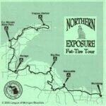
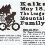
LMB has a long history of running successful bicycle events. Our popular multi-day tours attract riders from across the country. LMB even ran some mountain biking events in the late 1990’s and early 2000’s, including the Kalkaska Mountain Bike Family Tour and the Northern Exposure Fat-Tire Tour that rolled all the way to the tip of Copper Harbor. That was before suspension bikes were popular and well before the Keweenaw Peninsula was known as an international mountain biking destination, so admittedly, it’s been a while.
LMB’s Event Director, Neal Glazebrook, is an active mountain and gravel rider himself. He’s excited to add new gravel and off-road events into LMB’s portfolio in addition to our current paved offerings. Such events could help fund a dedicated LMB staff position to support trail advocacy, local trail projects, and local mountain biking clinics (which LMB piloted in 2021.)
We’ve heard a desire in the MTB community to bring back a points series for mountain bikers and bolster the race environment here in Michigan. With the recent spotlight and success of the Michigan Gravel Race Series promoting the gravel environment, Neal is brainstorming a plan to start a fresh MTB series in 2025. If you’re interested in being part of an exploratory event planning workgroup, get in touch at [email protected].
Additionally, LMB is making concerted efforts to ensure our annual Ride Calendar is inclusive and reflective of the entire cycling community, including gravel and mountain biking events and races.
If you are an event organizer, please be sure to submit your details to our online Ride Calendar!
What This Means for… Organizational Structure
Over the next several months, LMB staff will continue to work with the previous MMBA leadership on final housekeeping items related to the unification.
In the coming months, LMB’s Nomination and Cultivation Committee will begin to review candidates for our spring Board of Directors elections. We invite members of the mountain biking community to fill out our Board/Committee Interest Form should you be interested in serving in a leadership capacity on the board or one of our committees.
Beyond these opportunities, LMB has also established a high-level Michigan Mountain Biking Alliance Workgroup, consisting of members from the Michigan mountain biking community and representatives from existing trail associations. This hands-on committee advises LMB on needs and desires of the mountain biking community and provide guidance on next steps to ensure the future success of MMBA under LMB’s umbrella.
You can express interest in Board or Workgroup service by filling out the Board/Committee Interest Form.
We will share additional details as we solidify next steps with the MMBA Workgroup.
A future goal is to to secure sustainable funding to create a new dedicated MMBA staff position. In the short term, however, LMB will incorporate our entire team in MMBA transition efforts. Neal Glazebrook, LMB’s Events Director, and John Lindenmayer, Executive Director will serve as programmatic leads related to MMBA. Matt Penniman, Communications and Advocacy Director will spearhead legislative efforts.
What This Means for… the Future of LMB
In the medium to long term, we have some bold ideas and dreams for where we’d like to take MMBA under LMB. LMB hopes to:
- Tap into the deep knowledge bank of the existing mountain biking community to identify areas of need and opportunities for growth
- Build sustainable funding to create a new staff position dedicated to mountain bikes and trails
- Split the current Communications and Advocacy Director position into two separate staff assignments to ensure adequate resources for existing needs and new trail-specific issues
- Introduce trail and gravel focused rides into LMB’s portfolio of events
- Explore bringing back a race point series / awards & championships
- Secure new funding to bolster financial support for youth cycling programs around Michigan including mountain biking via LMB Micro-Grants and sponsorships
- Create a comprehensive mountain bike trails directory and advocate for an up-to-date detailed statewide DNR managed trail inventory that designates any user restrictions
What This Means for… You
To make this exciting new chapter a success, and effectively represent the Michigan mountain biking community moving forward, we need you. We invite you to put your excitement into action and join the thousands of other supporters across the state who have already become LMB members. Your membership in LMB will strengthen our voice and give us the standing to represent the MTB community with state lawmakers. Our strength is in our numbers as together, we advocate for the interests of ALL bicyclists across the great state of Michigan.
Thank you for trusting us to amplify your voice!